What is “Location” in GIS?

The defining character of geospatial analysis is that it requires access to the locations of the objects being analyzed. What is “location” in geospatial analysis?

The question may seem trivial to you now. However, you will appreciate its importance when you look for data for your geospatial analysis project. How do you know if a table or map you found can be used for your project? It all depends on if the locations are saved in or can be converted to the form required by geospatial analysis methods.

Think how you would answer the question “where is your college”. The answers could be “Northfield in Minnesota”, “1 North College St. Northfield, MN 55057”, or “by College and First St.”.

While we humans can communicate about locations with place names, street addresses, street intersections, locations expressed in these forms cannot be used by geospatial analysis software. To understand why, take a look at how GIS software compute the distance between two trees (the two points on the image below):

Euclidean Distance

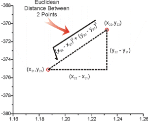
Modified from the image at https://hlab.stanford.edu/brian/making_measurements.html

Computers do not see maps as we humans. Computers see numbers. So some of the tasks that are very easily performed by humans without using numbers, for example, determining if a tree is within a particular park on a map, are done in GIS software with numeric computations.

As another example, in GIS, the question “if a tree (a point) is inside a park (a polygon)” is a point-in-polygon problem in computational geometry and is solved with a geometric algorithm. Here is an example of the algorithm used to solve the point-in-polygon problem and the coding in different programming languages used to implement the solution in computers.  

Additional examples of commonly performed tasks in GIS that are carried out with computations with coordinates are listed here:

  • Getting the area and perimeter of a college campus.
  • Mapping the area 15-ft from a fire hydrant where parking is not permitted.
  • Determining if two trails intersect, and if they do where the intersection is.
If you are interested in the role mathematics and computational geometry play in GIS, browse the table of contents of or read these books: (1) Mathematics of GIS by Wolfgang Kainz (this is a draft), (2) Mathematical Techniques in GIS by Peter Dal (3) Computational Geometry: Algorithms and Applications by Mark de Berg, etc.

It should be clear now why geospatial analysis requires locations saved as numeric coordinates, and why the reference coordinate system needs to be established on a mathematical surface that approximates the shape of the Earth, instead of the actual shape of the Earth.

Locations, however, are often recorded or communicated as textual descriptions for human uses. So there is a need to convert, or transform, these location descriptions to real-world coordinates that can be used in GIS.

Geocoding, or Address Mapping, is a process of converting location descriptions to coordinates. When you type in an address in Google Maps to get its location marked with a point on the map, it is geocoding working behind the scene. The coordinates of the address is identified with geocoding and then placed on the map which references a coordinate system.